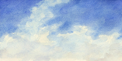
Showing posts with label altocumulus. Show all posts

Thursday, April 5, 2012

Soft pink night clouds

03/29/12, 10:50 pm, looking up
On overcast nights, when one looks up at the sky, the moving softness of clouds roiling above can be magical. These night altocumulus blew to the northeast (toward the bottom left). The deep blue darkness winking in between the pink fluffy clouds.


This March day was warmer than usual (in the mid-70's) and mostly overcast and breezy. 

Monday, March 12, 2012

Return of daylight saving time

03/11/12, 5 pm, looking northwest
Sunday marked the return of Daylight Saving Time (DST) in the US, or Summer Time to you in Europe. Since it is now DST from March to November, almost eight months, maybe we should call it Standard Time instead. We could call the current Standard Time "Winter Time" or "The Great Darkness".


The afternoon seemed endless and the light lasted until after 7 pm. That's why this little cloud study shows no trace of sunset colors even though it was painted after 5 pm. The sky was clear overall; I had to hunt low and just above the horizon for these soft altocumulus clouds. With a warming trend and possible rain this week, they will be more clouds to choose from.

Thursday, March 8, 2012

Another altocumulus and cirrus day

03/08/12, 9 am, looking northwest
Another warm day that began with cirrus clouds joined by low cumulus clouds. With a high today of 75 degrees F and gusting winds, the sky was a changing panorama of high and low clouds. Later in the day, the cumulus clouds grew in size to become massive towers racing across the sky.


A cold front is following this warm air coming through Central Virginia overnight bringing rain on Friday. Saturday is forecast to be clear and cool, a good night for enjoying a bonfire and a moon only two nights past full.

Wednesday, March 7, 2012

Warm cloudscape

02/07/12, 10 am, looking northwest
This beautiful spring-like (68 degrees F) day began with pale high cirrus clouds. As the morning went on, the altocumulus clouds began to move in low. One can see the more irregular rounded shape of the altocumulus clouds at the bottom of the painting.


By noon, the cirrus clouds had thinned or moved higher still. They were almost transparent. The cumulus clouds moved in a white fluffy pack across the sky floating gracefully northeast.

Thursday, February 23, 2012

Gauzy altostratus

02/23/12, 19:30 am, looking northwest
This morning was warm and sunny with altostratus clouds moving northeast. Today's high is forecast to be 73 degrees F. We are in a weather change to cooler temperatures and possible rain tomorrow. These clouds moved by at a brisk pace and by mid-day were succeeded by puffy little altocumulus clouds.


The challenge in painting clouds is to capture their indefiniteness and translucency. The way I've learnt to paint these thin, diaphanous clouds is more like staining the wet paper with the brush rather than making strokes with it. If I put on too much pigment, I dab it off and try again. I'll let the paper dry and then stain another layer over the first. Even though this painting looks very pale and light, there are at least four layers of pigment on the paper. Which is cold press watercolor paper, this time.

Wednesday, February 1, 2012

Cirrus with altocumulus

02/01/12, 10 am, facing northwest
More like April than January, today's high was 70 degrees F with an anticipated low of 49 degrees tonight. The crocuses are blooming along with some early daffodils. Coral pink quince blossoms dance in the warm breeze. Pansies hold their flowers high and dandelions bloom in the lawns.


Today's clouds began with an overcast sky that broke into this pattern of low cumulus and high cirrus clouds by mid-morning. We had a variety of clouds throughout the day with taller cumulus with dark, dramatic shadows developing later in the afternoon. Rain tonight.

Saturday, January 28, 2012

Polaris

01/25/12, 10 pm, looking north
Polaris (in upper left) shown forth against the encroaching altocumulus clouds on Wednesday night. We had a warm and damp front coming through. The clouds covered the sky by 11 pm, but at 10, there were large gaps in which the stars shown clearly.


Polaris is the North Star, or Pole Star, that marks the direction north. Polaris is a multiple star, composed of six stars that we know of. Polaris remains steady over the North Pole, one of the reasons it is used as an aid to navigation.


Polaris is the end of the handle in the Little Dipper, and the Big Dipper constellation circles around it in 24 hours. It is also the famous star in the Drinking Gourd (Big Dipper) that slaves in American followed to escape to free northern states and Canada.

Thursday, January 12, 2012

Weather change

01/12/12, 9:30 am, facing northwest
Yesterday's rain and low clouds gave way to this broken pattern of loose altocumulus blowing northeast with high cirrus above them. These clouds are the back of the rain that covered Central Virginia all day yesterday. Today's forecast of partly sunny and warm (60 degrees F) is the warm before the cold. Tonight will see a cold front move in from the west carrying with it a brief shower and a lows in the low 30's.


These soft, diaphanous layers covered the sky in all direction this morning, Thursday, January 12th, at about 9:30 am. Two hours later, all the cumulus clouds had blown away and just the high wispy cirrus remained. Even later in the day, it was all huge puffy cumulus clouds shadowed with violet.

Pink city glow

01/11/12, 9:30 pm, looking northwest
All day rain, low clouds and a damp chill. This glow was what I saw as I drove back from a rural area to the city just after 9 pm on Wednesday, January 11th. The low-pressure sodium (LPS) lamps in street lights cause the pink tint in the urban landscape. LPS reduces ambient light pollution and is less distracting for wildlife like migrating birds. 


The low-hanging altocumulus clouds hung in the sky like polyester batting and soaked up the pink LPS glow. Almost looks like cotton candy.

Thursday, January 5, 2012

Last day of the frigid front

Today's low was 17 degrees F according to Weather Underground, but the thermometer on the back porch read 12 when the dogs went out (briefly) at 5:15 am. The temperature will only go up for the rest of the day. Winter is here for the moment but the warmer temperatures of fall/spring are forecast for the rest of the week. 


A warm front moving into Central Virginia and displacing a cold front causes interesting cloud formations. This one was in the south just before 5 pm, a few minutes before sunset. Lots of layers here including cirrus, altostratus and altocumulus. Looks like a muddy gray curtain closing over the sky.

Thursday, December 29, 2011

Cloudy and getting cloudier

12/29/11,10 am, facing northwest
Well, cloudy and becoming cloudier. This morning there were a few cirrus clouds high in the atmosphere. By the time I painted this watercolor, loose altocumulus clouds had crossed the cirrus and these mixed layered clouds were on view. By noon, the sky was overcast, filled with a gray and low hanging mixture of clouds.


Puffballs

12/28/11, 10 am, looking north
These loosely-formed altocumulus clouds were blowing east in a cool, stiff breeze on Wednesday morning, December 28th. The altocumulus clouds had little solidity with misty edges and virga. Virga is visible precipitation falling from a cloud that evaporates before reaching the ground.

I have observed few days in which the wind blows directly east so far this year. This is one with winds up to 25 miles per hour and gust even stronger. One has to think these puffballs were being teased and torn apart as they blew due east.

Friday, December 23, 2011

Cloudy Solstice

12/21/11, 4 pm facing northwest
The Winter Solstice was cloudy and very warm in central Virginia this year, very unseasonable in my opinion. How unseasonably warm you ask? The high on Wednesday, December 21st was 66 degrees F; Thursday's high was 69 degrees.

With overcast skies full of altocumulus clouds almost bursting with rain, the warmth and humidity felt like springtime. All these clouds moved in from the southwest blanketing the east and moving northeast up the coast. This warm front precedes a cold front moving in on Friday.
12/22/11, 11:30 am, looking east

We had about a half inch of rain during the two days but most of those showers were sudden, brief and pelting. On Thursday morning the clouds broke up and thinned allowing glimpses of blue sky. Later in the day, we were deluged by heavy rain showers and oppressive warmth.

The clouds will thin and move north early Friday morning and we'll have steadily dropping temperatures throughout the day. So it will feel a lot more like Christmas!

Thursday, December 15, 2011

Breezy, lots of clouds

12/15/11, 10 am looking northwest
A cloudy night turns into a warm (65 degrees F) and breezy day with cirrus, stratus and altocumulus clouds scattered and layered in the blue. The wind must be very strong in the upper altitudes because after these altocumulus layers passed over by about 11 am, wispy cirrus clouds were revealed teased out like giant downy feathers.

A lovely day of warmth and open windows before winter makes us batten down the hatches. The sunset was a spectacular blend of blue violet and orange.

Wednesday, December 14, 2011

Clouding up

12/14/11 10 am, facing northwest
This morning the clouds moved in after yesterday's crisp clear skies. This is a warm front coming in advance of a cold front later in the week. By noon, the sky was overcast with little blue visible. There were a variety of cloud types including stratocumulus,  altocumulus and stratus.

Today and tomorrow are forecast to be warmer than normal with the promised cold front arriving on Friday with possible showers. Lots to paint!

Tuesday, December 13, 2011

Vein of marble

12/12/11 5:10 pm, altocumulus, facing south
These layered altocumulus clouds hung in the sky yesterday evening. I thought the shape was intriguing because it had bulges and loops of cloud hanging down. After the painting was dry, I thought it looked like marble, very cool and misty.

I chose to paint this unusual cloud rather than the blazing orange and purple sunset in the west. It reminded me so much of the sunset I painted on Thanksgiving (11/24/11), that I refrained. The sky was covered with low clouds turning gray and purple in the twilight, with a gap of orange sky above the horizon. The sun had set minutes before. Interesting how the southern view does not reflect any of that warm glow.

Thursday, December 8, 2011

Gray days

Two gray days full of altocumulus clouds making monochromatic ripples across the sky. Sometimes on the beach there are sand effects like this after several soft waves lap the gray-brown sand we have here on the coast of Virginia.


The top painting was done on Tuesday, December 6th at about 2 pm facing east. The bottom painting is from 4 pm on Wednesday, December 7th facing west. just before the deluge. Storms in central Virginia last night brought down trees and almost an inch of rain in just a couple of hours. Wind gusts of up to 70 mph broke tree limbs and caused hazardous driving conditions with many power outages (including my workplace!).


The mighty James River was the color of hot cocoa and dotted with large tree trunks and branches this morning (December 8th). The temperature plummeted by 25 degrees overnight and the sky is now clear. What a dramatic cold front--brrrr!

Tuesday, December 6, 2011

Clouds rolling in

The cirrus clouds of the past few days have given way to altocumulus with few breaks of blue sky. This warm front (high of 79 degrees F) is passing by before a cold front coming through tomorrow.


These sooty pink clouds wafted over Central Virginia yesterday afternoon, Monday, December 5th, at around 2 pm. I was facing the east as I painted them.

Monday, November 28, 2011

Cirrus and altocumulus

The bell weather cirrus clouds are now joined by some altocumulus clouds. This one caught the beginning of sunset colors at 4:30 pm on Sunday, November 27th. Notice that the cirrus clouds are too high to have any color reflected onto them. Only the low cumulus clouds shown with color at this early point in the sunset.


Our weather change continues with Monday's forecast including overcast skies, warm temperatures and rain overnight.

Saturday, November 5, 2011

Perfect fall day

Friday, November 4th was a perfect fall day with gentle breezes and orange and gold falling leaves. Rain came in the night and dawn was overcast. The afternoon sky was a clear cerulean blue deepening to ultramarine in the higher atmosphere. Small puffy clouds were blown south into the sunshine at 4 pm. They were lovely to watch, a fragile parade.


The clouds were between me and the sun and so the shadows were strong on each of these insubstantial fluffs. Apparently having a shadow is characteristic of altocumulus clouds which makes them easy to distinguish from high-atmosphere cirrocumulus clouds.


Art historian Kurt Badt, in The Cloud Studies of John Constable, proposes two perspectives to view Constable's cloud studies:
One can look at these cloud studies in two very different ways. One can observe their faithfulness to nature and their accuracy; (although that is not their most striking quality, it would be hard to find anything to equal them elsewhere in paintings of the atmosphere). Or one can approach them as pictures (albeit of strange subjects), as compositions, and then one will become aware of the intellectual element in them, or the 'poetic' element, to use the terminology of the Romantics.
In all the sky, an artist selects the compositions from the expanse before her. The challenge of creating a three-dimensional world on paper or canvas is great.